Terrestrial
Reference Frame
How can we provide a stable reference for measuring changes of our planet?
The International Association of Geodesy (IAG) recommends the International Terrestrial Reference Frame (ITRF) as the standard terrestrial reference frame for positioning, satellite navigation and Earth science applications, as well as for the definition and alignment of national and regional reference frames (see IAG Resolution No. 1, 2019). The importance of geodetic reference frames has been recognized by the United Nations, too. In February 2015, the UN General Assembly adopted its first geospatial resolution “A Global Geodetic Reference Frame for Sustainable Development”.
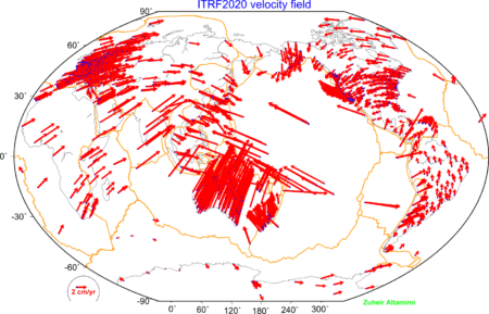
The ITRF provides the fundamental basis to refer the geodetic observations and estimated parameters to a unified global basis. High accuracy, consistency and long-term stability are required for precisely monitoring global change phenomena as well as for precise positioning applications on and near the Earth’s surface. The ITRF comprises concrete points (markers) attached to the solid Earth crust with precisely determined coordinates (mean 3D positions of the stations and their motions).
IERS – ITRS Centre
Within the International Earth Rotation and Reference Systems Service (IERS), the ITRS Centre (IGN, France) is responsible for the maintenance of the ITRS/ITRF, including network coordination, for providing the ITRS Combination Centers with specifications, and for evaluating their respective results. The ITRS Combination Centers are responsible to provide ITRF products by combining ITRF inputs from the Technique Centers and others. ITRS Combination Centers are currently maintained by IGN (Paris, France), DGFI-TUM (Munich, Germany) and JPL (Pasadena, USA).
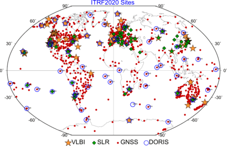
The latest realization, the ITRF2020 has been released by the ITRS Center in 2022. The ITRF2020 is based on the input data time series of station positions and Earth Orientation Parameters (EOPs) provided by the Technique Centers (IGS; ILRS; IVS; IDS) of the four space geodetic techniques GNSS, SLR, VLBI and DORIS). The new ITRS realization, the ITRF2020 is currently under development and will be released by the ITRS Center at the end of 2021.
Regional Densifications of the ITRF
Regional densifications of the global ITRF providing coordinates and time series of additional terrestrial sites or points needed to provide access to the global reference frame anywhere on the Earth’s surface. Such regional reference frames are defined, generated and maintained under the responsibility of regional organizations:
- Reference Frame Sub Commission for Europe (EUREF), IAG SC 1.3a
- Geocentric Reference System for the Americas (SIRGAS), IAG SC 1.3b
- North American Reference Frame (NAREF), IAG SC 1.3c
- African Reference Frame (AFREF), IAG SC 1.3d
- Asia-Pacific Reference Frame (APREF), IAG SC 1.3e
- Scientific Committee on Antarctic Research (SCAR), IAG SC 1.3


