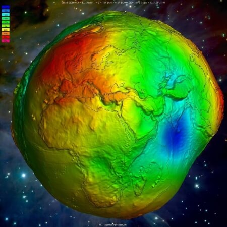
Global Gravity Field
Models
How and why does the Earth’s gravity change with location?
The precise knowledge of the Earth’s gravity field is fundamental to provide information about the Earth’s shape, its interior and fluid envelope. It is essential for many Earth system research areas, such as quantifying mass distribution and mass transport, monitoring oceanic transport, continental hydrology, ice mass balance and sea level, and dynamics of mantle and crust. With these contributions, global gravity field models are indispensable for an improved understanding of the Earth system and the interactions between its sub-components. Thus, these products are not only relevant for geodesy but also for other geosciences, such as geophysics, glaciology, hydrology, oceanography, and climatology.
Some applications and research fields that strongly depend on the precise knowledge of the Earth’s gravity field are:
- deriving physical heights that are crucial for many engineering, surveying and mapping operations;
- enabling the definition and realization of an International Height Reference System;
- monitoring mass distributions and its changes as indicators for climate change (e.g., ice melting) and for understanding of the global hydrological cycle (e.g., for water management);
- exploring minerals or fossil fuels, seeking out energy resources also from offshore locations and in deeper water;
- enabling precise orbit determination and predicting orbits of satellites and other space vehicles;
- exploring the interior structure and geological evolution of our planet.
Detailed Description
There exist different types of global gravity field models. First one can classify them as satellite-only and combined models. While satellite-only gravity field models are solely determined by observed orbit perturbations (e.g. CHAMP, GRACE, GRACE-Follow-On) and by satellite gravity gradiometry (GOCE), combined models are computed by adding terrestrial, airborne, ship and altimetric gravity observations to the satellite data. Second, they can be classified as static and time-variable gravity field models. Time variable gravity field models can only be determined from satellite data as they perform repeated observations depending on the chosen orbit and the satellite lifetime (e.g. time series of monthly models). All other data have been collected over decades and one hardly can define the observation epoch. Therefore, combined models can always be regarded as static (averaged) gravity field models. For satellite-only gravity field models this definition solely depends on the data coverage. With the data from dedicated satellite gravity missions, CHAMP, GRACE, GRACE Follow-On, and GOCE, it is now possible to represent the global Earth’s gravity field and its variations with much better spatial and temporal resolution, compared to the first-generation satellite-only global gravity field models computed between the 1960s to 1990s. Similar, more and better data of altimetry satellites as well as terrestrial, marine and airborne gravity measurements are used for the computation of high-resolution combined gravity field models with significant better accuracy and spatial resolution. Many institutions and agencies worldwide are computing such gravity field models for different applications by applying different mathematical approaches and analysis strategies.
IAG Services
Within the International Gravity Field Service (IGFS) of IAG, the International Centre for Global Earth Models (ICGEM), provides the scientific community with a state-of-the-art archive of static and temporal global gravity field models of the Earth. Since its establishment as an IAG Service in 2004, ICGEM has been collecting and archiving almost all of the existing global gravity field models available worldwide. Since a few years, ICGEM also collects temporal and topographic global gravity field models. After a validation procedure, these models are made publicly available in a standardized format with digital object identifiers (DOIs) assigned through GFZ Data Services. ICGEM also provides a web interface to calculate gravity field functionals on freely selected grids or user-defined coordinates, as well as a 3-D interactive visualization service for these functionals (geoid undulations and gravity anomalies) using static and time variable gravity field models. Furthermore, the users can perform quality checks of the models by comparing them with other models in terms of visualization and with respect to geoid undulations from other sources under the evaluation page. ICGEM’s interactive calculation and 3-D visualization services are excellent tools not only for geodesists but also for students and Earth scientists from other disciplines. Please cite the ICGEM Service by providing the reference (Ince et al., 2019) as given below.
Product Center – COST-G
In 2019, the International Combination Service for Time-variable Gravity Fields (COST-G) has been established as a new Product Center of IAG’s International Gravity Field Service (IGFS). The main products of COST-G are monthly global gravity field models with improved quality, robustness, and reliability both in terms of spherical harmonic coefficients and thereof derived grids of surface mass changes by combining solutions or normal equations from COST-G analysis centers. Different products at different processing levels are provided in particular for GRACE Follow-On, GRACE and SWARM satellites, such as monthly spherical harmonics models stemming from the combination (Level-2 products), post-processed products with various corrections applied (Level-2b products) and user-friendly grids based on Level-2b products (Level-3 products) for various scientific applications (Jäggi et al., 2020).


