GGOS Coordinating Office
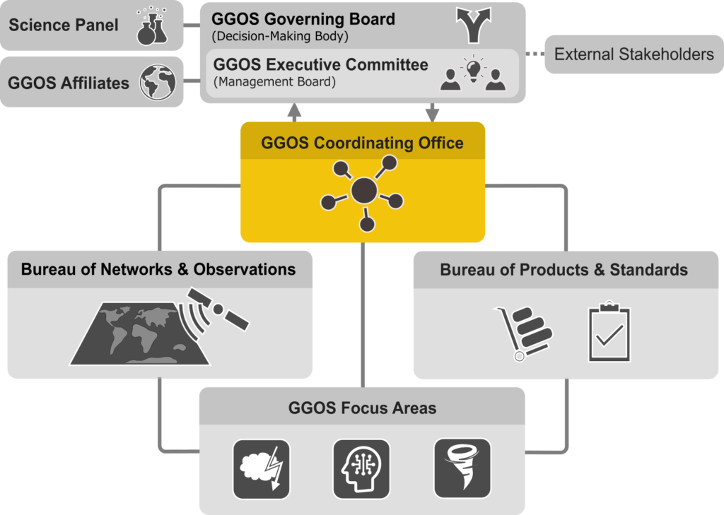
The GGOS Coordinating Office serves as the Secretariat of GGOS, coordinates the administrative work in support of the various GGOS structural elements, and is responsible for outreach and communications. The GGOS Coordinating Office ensures information flow, maintains documentation of the GGOS activities, and manages specific assistance functions that enhance the administrative coordination across all areas of GGOS, including inter‐services coordination and support for meeting and workshops. The GGOS Coordinating Office, in its long‐term coordination role, ensures that the GGOS components contribute to GGOS in a consistent and continuous manner. The GGOS Coordination Office also maintains, manages, and coordinates the GGOS web and social media presence.
- Director: Martin Sehnal (BEV, Austria)
- Manager of External Relations: Allison Craddock (NASA/JPL, USA)
- GGOS Web and Social Media Manager: Helmut Klima (BEV, Austria)
- Assistant: Lucas Triebenbacher (BEV, Austria)
Objectives
GGOS internal tasks:
- Supporting the GGOS President, Executive Committee, Governing Board and Science Panel
- Ensures the coordination of GGOS components (Bureaus and Focus Areas) activities
- Ensures information flow
- Maintain documentation of the GGOS activities
GGOS external tasks:
- Managing and maintaining of the GGOS web and social media presence
- Organization and support of meetings, conferences and workshops
- Enhance inter‐services coordination
- Managing of external relations
Recent Activities
Recorded presentations about recent developments and future plans in the GGOS Coordinating Office (from GGOS Days 2022):
GGOS Portal
Unique Metadata Platform for Geodetic Data and Products
More info … (https://ggos.org/portal/)
Manager of External Relations
The position of Manager of External Relations resides within the GGOS Coordinating Office. The Manager of External Relations coordinates, in consultation with the GGOS President, GGOS engagement with external organizations such as the Group on Earth Observations (GEO), the Committee on Earth Observation Satellites (CEOS), the International Science Council (ISC) World Data System (WDS), the Federation of Surveyors (FIG), the UN Global Geospatial Information Management (UN-GGIM) Subcommittee on Geodesy (SCoG), and the UN Global Geodetic Centre of Excellence (UN-GGCE). The GGOS Governing Board elects the Manager of External Relations by vote.

Allison Craddock
Committee on DOIs for Geodetic Data Sets
The Coordinating Office also works to identify opportunities for improved coordination and advocacy within the geodetic community, establishing the Working Group on “Digital Object Identifiers (DOIs) for Geodetic Data Sets” in 2019, which was transformed to a GGOS Committee in 2023. This GGOS Committee consists of more than 20 members affiliated with IAG Services, working to establish usage parameters and advocate for the consistent implementation of DOIs across all IAG Services and in the greater geodetic community.

Kirsten Elger
Headquarter of Coordinating Office
The GGOS Coordinating Office is based at BEV (Austrian Federal Office of Metrology and Surveying) in Vienna/Austria since 2016.
Federal Office of Metrology and Surveying
(BEV – Bundesamt für Eich- und Vermessungswesen)
Schiffamtsgasse 1-3
1020 Vienna, Austria


