Sea Surface Heights
How can the height of oceans be observed?
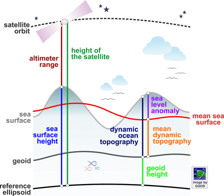
Satellite altimetry systems are designed to map the sea surface. These systems measure the satellite-to-sea surface round-trip travel time of radar or light pulses to determine the height of the satellite (altimetric range) above the instantaneous sea surface. The difference between the satellite altitude above a reference surface and the altimetric range provides the sea surface height with respect to the same reference surface. The range from the satellite to the sea surface is corrected for various components of the atmospheric refraction and to mitigate effects caused by instrumental biases and sea state induced systematics. A number of corrections due to different geophysical effects are also taken into account. Different products are distinguished:
Sea Surface Height (SSH)
Sea Surface Height (SSH) is the height of the sea surface above a reference ellipsoid. This is the direct product of satellite altimetry. Sea surface height values are provided along the satellites’ ground tracks or at regular grids interpolated from the values determined along the satellite tracks. Instantaneous sea surface height values contain long-term, annual, seasonal and short-term temporal variations of the ocean surface.
Mean Sea Surface (MSS)
Mean Sea Surface (MSS) is the long-term average of the sea surface height (at least over one year). Usually, ocean tides are reduced from the sea surface height values before computing the mean sea surface. Mean sea surface values are provided at regular grids for different time lengths (typically multi-year mean values).
Sea Level Anomalies (SLA)
Sea Level Anomalies (SLA) are the deviations of the sea surface from the mean sea surface; i.e., SLA = SSH – MSS.
Dynamic Ocean Topography (DOT)
Dynamic Ocean Topography (DOT), also called Absolute Dynamic Topography (ADT) or Ocean Surface Topography (OST) is the difference between the instantaneous sea surface height and the geoid. It contains contributions from high- and low-frequency changes in steric (temperature and salinity) signals, ocean circulation, winds, eddies, and propagating planetary waves.
Mean Dynamic Topography (MDT)
Mean Dynamic Topography (MDT) is the averaged dynamic ocean topography over a time period and it is considered semi-stationary. It corresponds to the ocean relief (therefor, it is also called Sea Surface Topography – SSTop) and the gradient is related to the time-mean surface geostrophic circulation. It is also related to upper ocean density (temperature and salinity) as well as the time-mean currents.
Mean Sea Level (MSL)
Mean Sea Level (MSL) is the local sea surface height averaged over a long period in a certain region. It can be also determined from tide gauge records.
Global Mean Sea Level (GMSL)
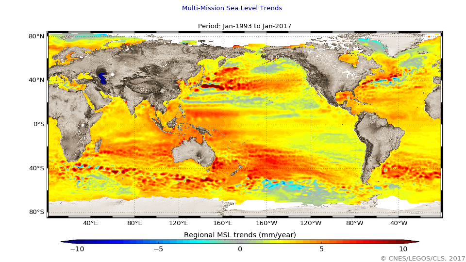
Global Mean Sea Level (GMSL) is the mean sea level averaged across all the oceans of the globe. This is usually provided as a time series and used to compute the GMSL trend.
Satellite altimeters cover the ocean areas with repeated tracks at repetition rates of some days and permit the estimation of sea surface heights to an accuracy of 1 to 2 cm. The original altimetry data measured by the individual satellite altimetry missions are provided by the responsible space agencies. Some of them also provide pre-processed sea surface heights (so-called Level-3 or Level-4 products). Refined solutions are computed by different agencies, universities and research institutes, who provide their results in grids of few minutes of arc. These products differ with respect to the used data sets, the considered time span, and the processing strategies and methods.
Satellite altimetry enables a nearly global and quasi-continuous monitoring of the sea level with cm-accuracy. The comparison of altimetry solutions referring to different epochs allows the estimation of sea surface and sea level variations, which provide insights in the redistribution of oceanic water masses, thermal expansion and contraction, ocean current variability and eddies, density variations due to water temperature and salinity, atmosphere-ocean coupling, as well as exchange with fresh waters, including melting ice sheets and glaciers.


