DOT – Dynamic
Ocean Topography Models
What are dynamic ocean topography models and why are they needed?
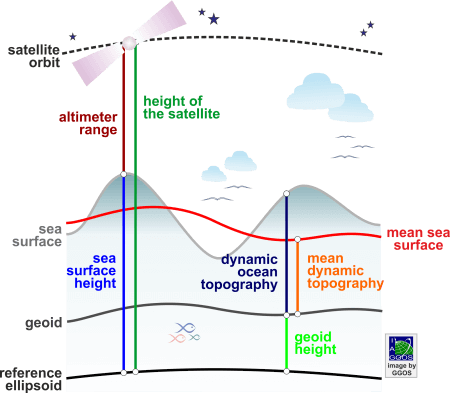
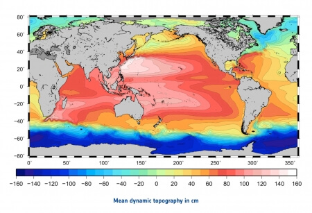
Dynamic Ocean Topography (DOT) is the difference between the instantaneous sea surface height and the geoid (the equipotential surface of the Earth’s gravity field that is most closely approximated by the mean instantaneous sea level). DOT contains contributions from wind and other high frequency effects like tides, currents, and the loading of atmospheric pressure. DOT is also known as Absolut Dynamic Topography (ADT) or Ocean Surface Topography (OST). Mean Dynamic Topography (MDT) is the averaged DOT over a time period and it is considered semi-stationary. MDT is mainly caused by nearly constant oceanographic and meteorological effects, which generate ocean currents and ocean surface slopes. It is also called Sea Surface Topography (SSTop).
Dynamic ocean topography models are usually provided in regular grids. They are derived from the sea surface heights measured with satellite altimeters and global geoid models of high precision. The original altimetry data measured by the individual satellite altimetry missions are provided by the responsible space agencies. Some of them also provide pre-processed sea surface heights (so-called Level-3 or Level-4 products). Refined solutions are computed by different agencies, universities and research institutes, who provide their results in grids of few minutes of arc. These products differ with respect to the used data sets, the considered time span, and the processing strategies and methods. Global geoid models are provided by the International Centre for Global Gravity Field Models (ICGEM).


