Earth Orientation
Parameters
Why are days getting longer and Earth is wobbling?
The Earth Orientation Parameters (EOP) are the parameters representing the rotational part of the transformation between the current releases of the International Celestial Reference Frame (ICRF) and the International Terrestrial Reference Frame (ITRF). Accordingly, the EOP describe the change of the orientation of the Earth’s surface, on which the observatories are located, with respect to a space fixed reference frame. Earth rotation refers to the solid Earth component of the dynamic Earth system excluding deformations, such as tides and continental drift. Through interactions of individual components, angular momentum can be transferred between the atmosphere, ocean, and solid Earth, or between the Earth’s core and mantle due to the coupling mechanisms.
The following examples give an overview of the relevance of the knowledge of accurate Earth orientation parameters:
- Realization of reference frames on Earth and in space
- Precise positioning and satellite navigation
- Precise orbit determination (POD)
- Realization of time systems (e.g. monitoring of the duration of days)
- Earth system studies (e.g. climate change)
More specifically, the EOP are a set of five time-dependent parameters that describe the difference in orientation of GCRS- and ITRS-compatible 3-vectors,
![]()
while maintaining their magnitudes ![]() . The axes directions of GCRS are obtained from the positions of extra galactic objects, whereas the axes directions of ITRS are determined from coordinates of reference points of stations of space geodetic techniques on the Earth surface.
. The axes directions of GCRS are obtained from the positions of extra galactic objects, whereas the axes directions of ITRS are determined from coordinates of reference points of stations of space geodetic techniques on the Earth surface.
The 5 Earth Orientation Parameters are:
![]() - Celestial Pole Offsets (given by Precession, Nutation models)
- Celestial Pole Offsets (given by Precession, Nutation models)
The Corrections ![]() (Celestial Pole Offsets – CPO) to the celestial pole coordinates (
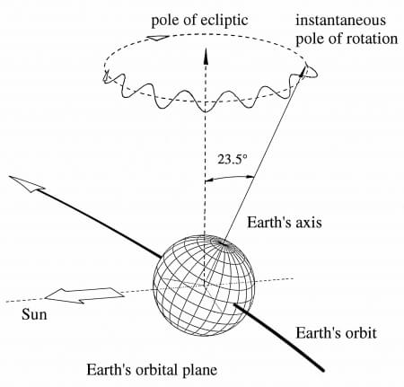
(Celestial Pole Offsets – CPO) to the celestial pole coordinates (![]() ) are given by the IAU 2006 precession and IAU 2000A nutation models. Difference of the position of the rotation pole at date, the celestial intermediate pole (CIP), to the conventional celestial north pole at epoch (J2000.0) in Cartesian coordinates. Alternatively, the precession-nutation can be expressed in spherical coordinates
) are given by the IAU 2006 precession and IAU 2000A nutation models. Difference of the position of the rotation pole at date, the celestial intermediate pole (CIP), to the conventional celestial north pole at epoch (J2000.0) in Cartesian coordinates. Alternatively, the precession-nutation can be expressed in spherical coordinates ![]() and
and ![]() (angular units). If
(angular units). If ![]() and
and ![]() are known, the celestial intermediate origin (CIO) locators can be computed with a model to sufficient accuracy. Some algorithms still use the alternative ecliptic-based paradigm and thus some authors provide the classic precession/nutation angles
are known, the celestial intermediate origin (CIO) locators can be computed with a model to sufficient accuracy. Some algorithms still use the alternative ecliptic-based paradigm and thus some authors provide the classic precession/nutation angles ![]() instead of
instead of ![]() .
.
![]() - Earth Rotation Angle (related to
- Earth Rotation Angle (related to ![]() )
)
The ![]() (unit typically in radiant) is a sidereal time expressed on the CIP equator after accounting for the CIO and Terrestrial Intermediate Origin (TIO) locations.
(unit typically in radiant) is a sidereal time expressed on the CIP equator after accounting for the CIO and Terrestrial Intermediate Origin (TIO) locations. ![]() is related to the mean solar time
is related to the mean solar time ![]() (unit: second) through a fixed linear proportional relation to
(unit: second) through a fixed linear proportional relation to ![]() . As
. As ![]() is of high practical relevance, it is thus often reported instead of
is of high practical relevance, it is thus often reported instead of ![]() .
.
![]() - Pole Coordinates (Polar Motion)
- Pole Coordinates (Polar Motion)
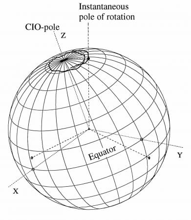
The pole coordinates (typically in angular unit) of the celestial intermediate pole (CIP) in the ITRS due to the polar motion (PM). The TIO locator ![]() is a function of the pole coordinates and their first-time derivatives and can be computed with a model to sufficient accuracy.
is a function of the pole coordinates and their first-time derivatives and can be computed with a model to sufficient accuracy.
International Earth Rotation and Reference System Service – IERS
In this context, the terminology of rotation pole or rotation axis is specific for the diurnal revolution of the Earth (ERA), excluding the remaining smaller components of the true angular velocity. The International Earth Rotation and Reference Systems Service (IERS) is responsible for disseminating the EOP time series on operational basis derived from space geodetic techniques, including VLBI, SLR, GNSS and DORIS provided by the corresponding IAG Services, i.e., IVS, ILRS, IGS and IDS. Highly accurate CPO and UT1 are exclusively obtained by VLBI, whereas the satellite-based techniques can provide polar motion, length of day (LOD) and their first time derivatives with high precision and temporal resolution. If a sufficient number of normal points is available, LLR will be able to provide UT1 with an accuracy comparable to the VLBI results. The satellite-based techniques can refer their observations to GCRS only indirectly and in case the line of ascending node, perigee distance and inclination of the respective orbits are known.


