Satellite Altimetry
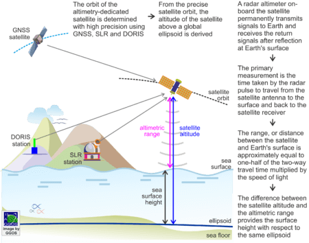
Altimetry-dedicated satellites are equipped with a sensor, which transmits microwave pulses in the radar frequency domain or laser pulses in the optical or infrared domain to the ground and receives the return signals after reflection at Earth’s surface. Because of the favourable reflective properties of water, the radar observation technique is especially suitable over oceans and open water on land. The primary measurement is the satellite-to-water surface round-trip travel time of the signal, multiplied by the speed of light, is equivalent to the round-trip distance. Thus, the range, or distance between the satellite and the instantaneous sea surface is approximately equal to one-half of the two-way travel time multiplied by the speed of light.
The altitude of the satellite above a global ellipsoid is derived from an orbit computation with respect to a geocentric reference frame (e.g. the International Terrestrial Reference Frame – ITRF). The difference between the satellite altitude and the altimetric range provides the sea surface height with respect to the same ellipsoid. The range from the satellite to the sea surface is corrected for various components of the refraction in the troposphere and ionosphere and to mitigate effects caused by instrumental biases and the sea state (for example, the presence of waves in the ocean). A number of corrections due to different geophysical effects are also taken into account.
Altimetry measurements can also be made using a laser altimeter, which operates in a very similar way to radar technology but using light pulses. Laser altimetry exists in three forms: satellite laser altimetry, light detection and ranging (LiDAR) aerial survey, and terrestrial LiDAR survey. Laser altimetry is widely used for the generation of digital elevation models. Satellite radar and laser altimetry have proved very useful for measure the change in elevation of ice sheets (hence their mass balance in response to global warming) and more recently to measure the water level of lakes, rivers and floodplains on land.
Applications
The main significance of satellite altimetry results from the possibility of scanning synoptically large ocean areas within a short time period and determining a detailed representation of the sea surface with high resolution in space and time. Measurements along ground tracks that repeat after a set number of orbits mean that the altimetry data can provide a consistent sample of the sea surface height through time on a fixed geographic grid. The wealth of data from satellite altimetry provides the best overall approach for the determination of the marine gravity field (gravity anomalies, gravity disturbances, geoid models, etc.). Current satellite altimetry missions provide sea surface heights with an accuracy of about 1 – 2 cm for a single measurement. The precise determination of the temporal variations of the sea surface allows a detailed research in numerous oceanographic applications, like surface currents, ocean dynamic topography, ocean seasonal changes, El Niño effect, ocean heat content, sea level rise, ocean tides, etc. The fine structure of the mean sea surface, derived from high-resolution satellite altimeters, reflects ocean bottom topography and tectonic structures of the oceanic lithosphere, and contributes significantly to marine geophysics. The high frequency of track repetitions together with the centimetre resolution provides a powerful means for continuous monitoring of ocean surface variability and related processes in oceanography. Dedicated missions with high orbit inclination offer unprecedented opportunities to map and monitor the polar ice sheets.


