Satellite and Lunar Laser Ranging
SLR / LLR
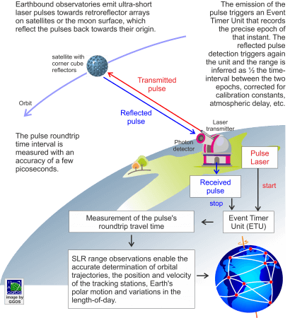
Laser distance measurements are made from ground stations to satellites equipped with corner cube reflectors (SLR) or to retroreflectors on the moon surface (LLR). SLR and LLR use very short laser pulses and fast electronics and detectors to measure the pulse’s instantaneous roundtrip-time-of-flight to the satellites or to the moon. Using the time interval between emission and reception of the ultra-short laser pulses at the same station, engineers infer the precise ranges which analysts use to determine the satellite position at the time of reflection. New laser systems operate at kilohertz (kHz) rates; legacy systems (soon to be replaced) operate at rates of 5 – 10 Hz. Data are aggregated by means of statistical averaging into normal points over intervals of 5 seconds to 5 minutes depending on the altitude of the satellite.
LLR is more challenging than SLR because of the need for more accurate pointing (arcseconds) and the need to detect the much weaker signal that return from the moon. Larger, more powerful laser systems with more sophisticated signal detection systems need to be employed in LLR; consequently, there are far fewer stations that range to the moon than range to artificial satellites, although the introduction of the kilohertz lasers has reduced this requirement.
SLR / LLR Network
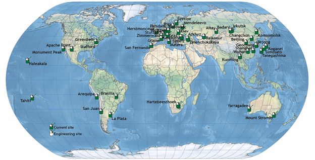
The international network of about 40 SLR and 4 LLR stations routinely track over 120 satellites at altitudes ranging from 250 km to 35,000 km and six reflector arrays (Apollo and Lunokhod) placed on the surface of the moon.
Depending on satellite altitude and the constraints of the observation program, some 10 to 100 ranges (normal points) can be measured during one passage. Currently, the single-shot precision is 5 mm to 10 mm; normal point precisions are typically in the 1 mm range or better. At present, a large number of satellites are equipped with laser reflector arrays and are used for geodetic positioning and crustal deformation monitoring, determination of Earth rotation parameters, gravity field modelling, and precise orbit determination. LLR contributes especially to the study of the dynamics of the Earth-moon system, lunar ephemerides and libration, connection of celestial and terrestrial reference frames, fundamental theory tests, research on terrestrial geodynamic processes and the lunar interior.
Applications
Due to the very high accuracy potential of laser ranging observations to satellites a broad field of applications in Geodesy and Geodynamics opened early on. The SLR contribution is of utmost importance for
- the determination of polar motion and variation in the length of day
- the realisation of the origin of the terrestrial reference frame (unique contribution!)
- the realisation of the scale of the terrestrial reference frame (together with VLBI)
- monitoring the movement of Earth’s centre of mass with respect to the ground stations
- the estimation of static and time-variable components of Earth’s gravity field
- satellite orbit determination
- tectonic plate motion and surface deformation
- tide modelling, precise time transfer, relativity, etc.
Services
The International Laser Ranging Service (ILRS) collects, analyses and provides the SLR/LLR datasets from the existing and historic stations. In addition to the ephemerides of the observed satellites, ILRS produces weekly solutions of precise station positions and time series of Earth orientation parameters. The contribution of SLR/LLR to the determination of the terrestrial reference frame and Earth orientation parameters is combined with the contributions from the other space techniques by the International Earth Rotation and Reference Systems Service (IERS). The contribution of SLR to the modelling of Earth’s gravity field is combined with other gravimetric and geopotential mission observations by the International Gravity Field Service (IGFS).


