Tide Gauge Measurements
For over 200 years, we have been observing the height of the ocean using tide gauges. Perhaps more accurately called water level sensors, as they can be used in areas where there is little or no tide, they can be used to monitor variations in heights across a wide range of timescales, from high frequency waves, storm surges and tides, to long term changes in ocean currents, changes due to the expansion of warming water, and the melting of glaciers and ice caps.
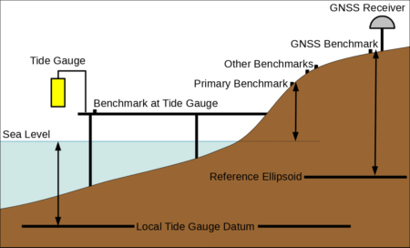
A typical tide gauge – water heights are effectively tied to a physical point on land, the primary benchmark, by measuring heights above a local tide gauge datum defined a fixed distance below the benchmark. The stability of the primary benchmark is monitored by regular comparison with a network of nearby benchmarks. Ideally, local land movement should be monitored by co-locating the sites with a GNSS receiver.
The earliest gauges were simple marked staffs on harbour walls which an observer would use to read water levels. During the 19th century automatically recording gauges were developed, where a float on the water was attached by a system of pulleys to a pen which would draw levels on a rotating chart. Modern sites tend to either rely on pressure sensors in the water, or acoustic or radar sensors measuring heights by bouncing beams off the surface from above. Recent developments have shown that GNSS receivers can be used as tide gauges by comparing the direct signal with the multipath reflection off the surface of the water.
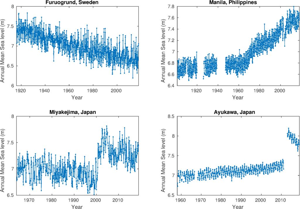
Tide gauges actually measure relative sea level, that is the height of the sea relative to a fixed point on land, usually a physical marker called a benchmark. Thus, changes in relative sea level can also result from local movements in the land. For this reason, tide gauges have played an important historical role in geodesy. Some of the earliest records come from the Baltic, where apparently falling sea levels result from land still rising after being compressed under ice sheets during the last glacial period. Tide gauges were also used to define Mean Sea Level for many national and regional levelling systems.
Co-locating tide gauges with other geodetic sensors that measure land movement, such as GNSS receivers, can enable us to separate the sea level part of the signal from the portion due to local land movement. However, even then the sea level can be affected by other geophysical processes, such as crustal motion or variations in gravity.
Examples of land movement signals in tide gauge records. In Furuogrund, land rising faster than sea levels due to recovery post ice age produces an apparent falling trend. In Manila, rising sea levels are exacerbated due to rapid subsidence caused by groundwater extraction. Ayukawa shows a sudden land movement due to 2011 Tōhoku earthquake. Miyakejima, a volcanic island, shows a rapid period of subsidence following an eruption. (Image: PSMSL, Data: Swedish Meteorological and Hydrological Institute; National Mapping and Resource Information Authority, Phillipines; Japan Meteorological Agency; Japan Oceanographic Data Center).


