Satellite-based
gravity field observations
According to Newton’s law of gravitation, the attraction between two bodies is proportional to the product of their mases and inversely proportional to the square of the distance between them. If a satellite passes above an Earth’s mass inhomogeneity (or anomaly), its trajectory (orbit) has a perturbation, i.e., the satellite position gets closer or further away from the Earth. The lower the satellite, the higher its sensitivity to the gravitational effect caused by the mass inhomogeneity. The satellite motion and the parameters describing the orbit are observed to draw conclusions about the forces acting on the satellite. Of particular interest is the relation between the features of the terrestrial gravity field and the resulting deviations of the true satellite orbit from an undisturbed, ideal satellite motion.
The traditional tracking techniques used for satellite positioning (GNSS, SLR and DORIS) allow the precise orbit determination for satellites with altitudes between 800 km and 20,000 km, which in turn allow the determination of the Earth’s gravity field with a resolution of about 500 to 1000 km (half wavelength). To increase this resolution, dedicated high-resolution gravity-field missions have been developed. The essence of these is the use of satellites as gravity probes or sensors moving within the Earth’s gravity field. The main characteristics of these satellite missions are:
– Orbit altitude as low as possible (200 to 500 km)
– Uninterrupted tracking over large orbital arcs in three spatial dimensions, and
– Separation between gravitational and non-gravitational forces (e.g. atmospheric drag, solar radiation pressure, albedo, thrust, etc.) acting on the satellite.
The main observation principles are:
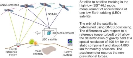
– Satellite-to-satellite tracking in the high-low mode (SST-HL): a low Earth orbiting (LEO) satellite is tracked by high orbiting GNSS satellites, relative to a network of ground stations. The satellite is a probe within the Earth’s gravity field, which can be precisely tracked without interruption. The observed 3-D accelerations correspond to the gravity accelerations. The non-gravitational forces acting on the satellite are measured by accelerometers. An example of this measuring principle is given by the mission CHAMP (CHAllenging Minisatellite Payload)
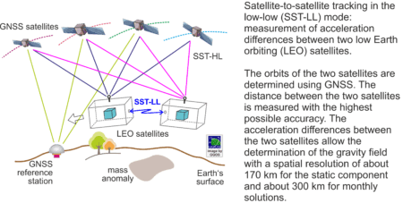
– Satellite-to-satellite tracking in the low-low mode (SST-LL): Two LEO satellites are placed in the same orbit, separated by several hundred kilometres, and the range (distance) between them is measured with the highest possible accuracy. Basically, the acceleration difference between the two satellites is measured. The two satellites can be considered as one instrument in which
(1) Variations in the gravity field cause variations in the range between the two satellites: areas of stronger gravity affect the lead satellite first and accelerate it away from the second satellite,
(2) Range variations are measured by a high-accuracy microwave link or laser-ranging interferometry,
(3) The observed range variations are corrected for non-gravitational effects by precise accelerometers.
This method provides a very much higher sensitivity than SSL-HL. Examples of this measuring principle are the GRACE (Gravity Recovery and Climate Experiment) [Link1, Link2] and GRACE Follow-On (GRACE-FO) missions [Link1, Link2, Link3]
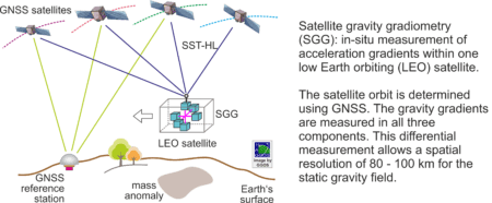
– Satellite gravity gradiometry (SGG): Acceleration differences in all three dimensions are measured directly within a LEO satellite. One important advantage, compared to SST-HL and SST-LL, is that non-gravitational accelerations are the same for all measurements inside the satellite and hence vanish by differentiation. An example of this measuring principle is the mission GOCE (Gravity field and steady-state Ocean Circulation Explorer)
Applications
Data provided by satellite gravity field missions are essential for the determination of the Earth’s gravity field, the computation of geoid, the vertical datum unification, and for the establishment of a global unified height system such as the International Height Reference System (IHRS). The dedicated gravity field missions CHAMP, GRACE (and GRACE Follow-On) and GOCE have made to a huge improvement to our knowledge of the Earth’s static and time-variable gravity field. These missions have considerably increased the accuracy of the static gravity field by a factor of at least 100 in terms of resolvable spatial scales compared to pre-CHAMP gravity models, which were mainly determined from satellite laser ranging data. Global gravity models based on GOCE data offer accuracies at the 2 cm level in terms of geoid height at a resolution of 80 to 100 km. Based on monthly gravity fields determined from CHAMP and in particular, GRACE data, seasonal variations and trends in the Earth’s gravity field can be monitored, providing unique information about relevant mass transport phenomena like water cycle in larger river basins, the melting of ice sheets in Antarctica and Greenland and the associated sea level change, as well as in the ocean current systems.
Services
Static global gravity models and time-variable gravity models are available at ICGEM.


