GGOS-Portal
Idea of a Unique Platform for Geodetic Data and Products
The services of the International Association of Geodesy (IAG) provide very important and valuable geodetic data, information, and data products that are increasingly relevant for Earth System research, including monitoring of global change phenomena and a wide range of diverse applications such as satellite navigation, surveying, mapping, engineering, geospatial information systems, and so on.
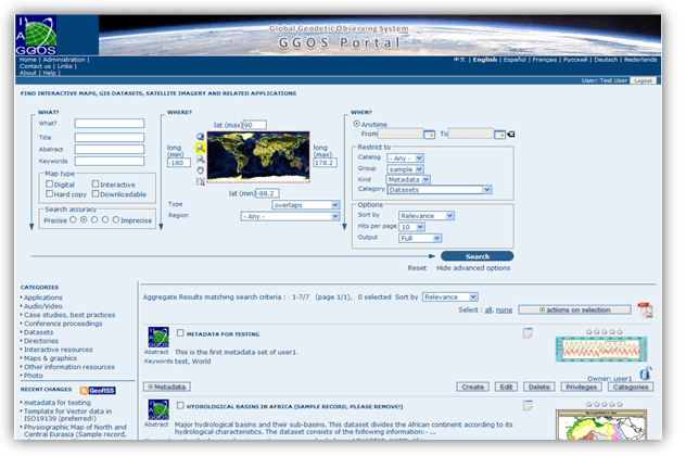
Currently, it is difficult for many people to obtain an overview of all available geodetic products and data. The Global Geodetic Observing System (GGOS) of the IAG aims to fill this gap by developing the GGOS-Portal, which will serve as a unique search and access point for geodetic data and products (one-stop shop). Data and products will be described by detailed metadata and remain physically located at their originating data centers of each contributing IAG service and other data providers. The GGOS-Portal will only synchronize the provided metadata and include it in its platform to ensure better discoverability. In the long term, the GGOS-Portal can provide a set of tools for organized knowledge search, including visualization to support identification and selection of appropriate resources (information, data, products).
In general, geodetic data portals are a dime a dozen. However, the GGOS portal will be much more than just a data portal for geodetic data from the IAG Services. The combination of the easy understandable descriptions of products and observation techniques with this comprehensive source of detailed geodetic metadata makes the future GGOS portal unique.
Prominent examples for existing Metadata Portals are the GEOSS-Portal, the GNSS Metadata Portal Europe, the EPOS: GNSS Product Portal Europe and the Metadata Information System at BKG, Germany.