BPS – GGOS Bureau of
Products and Standards
Overview
The Bureau of Products and Standards (BPS) is chaird by the Deutsches Geodätisches Forschungsinstitut, Technische Universität München (DGFI-TUM) and operated jointly with TUM’s Chair of Astronomical and Physical Geodesy within the Research Group Satellite Geodesy (Forschungsgruppe Satellitengeodäsie, FGS). Further involved partners are GFZ (German Research Centre for Geosciences, Potsdam) and DLR (German Aerospace Centre, Oberpfaffenhofen).
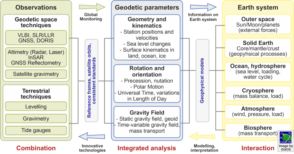
The BPS supports GGOS in its goal to obtain highly accurate, consistent and long-term stable geodetic products describing the Earth’s size, shape, rotation and gravity field as global functions of space and time. This is a fundamental requirement for reliably quantifying our planet’s changes due to geodynamic processes and ongoing climate change as well as for numerous positioning and satellite navigation applications. The following Figure illustrates the integration of different observation types to determine consistent geodetic parameters as the basis for studies of the Earth system.
Figure: Integration of geodetic observation techniques into consistent parameters for Earth system research.
latest presentation about the GGOS BPS at the GGOS Days
The interaction between the observation techniques, the geodetic parameters and the Earth system components takes place in two directions. (1) The geodetic parameters for the geometry and kinematics, the Earth rotation, and the gravity field as well as the underlying reference frames and satellite orbits are obtained by processing and combining the geometric and gravimetric observations and they provide information about the Earth system and its components. (2) Conversely, the physical processes in the Earth system and the interactions among its components and with external bodies (Sun, Moon, planets, etc.) transmit signals that are captured by geodetic observation techniques and mapped into the estimated parameters. Consequently, improved modeling of Earth processes can also improve the data analysis and lead to more consistent and precise geodetic parameters. In order to fully utilize the accuracy of the geodetic observations, not only highly accurate and stable reference frames are required, but also the implementation of common standards, conventions and consistent (geo)physical models.


