Very Long Baseline Interferometry
VLBI
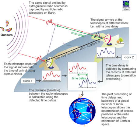
VLBI is a space geodetic technique based on radio astronomy. Radio signals emitted by extragalactic sources (quasars: quasi-stellar radio sources, radio galaxies) are captured by a pair of directional antennas (radio telescopes) located on the Earth’s surface. Due to the different position of the antennas, the same signal arrives at each antenna with a slight time difference ranging from 0.003 to 0.050 seconds. This time delay is measured to a precision of few trillionth of one second (picosecond) with sophisticated atomic clocks installed at each antenna. By multiplying the time delay with the speed of light, the distance between the two antennas can be determined with an accuracy of few millimetres.
The time delay between the arrival times of the same signals at the two antennas is inferred by a comparison (cross-correlation) of the signals received at each antenna. The comparison process consists of a relative shifting of the signals until a maximum correlation is found. Using antennas widely separated (a few 1,000 to 12,000 km) ensures a measurement accuracy of few picoseconds.
VLBI Network
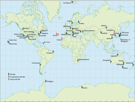
Therefore, a globally distributed VLBI network is of uppermost importance. A VLBI observation session usually includes between eight to ten radio telescopes observing about 60 quasars several times in a period of 24 hours. The observation sessions are scheduled to have overlapping baselines including all VLBI stations distributed over the complete Earth’s surface. The VLBI radio telescopes form geometrical networks between the baselines and the time delays from each baseline in the network are used to determine the relative positions of the antennas to a few millimetres and the quasar positions to fractions of a milliarcsecond.
Applications
VLBI plays a fundamental role in Geodesy and Astrometry for
- the establishment and maintenance of the International Celestial Reference Frame (ICRF)
- the establishment and maintenance of the International Terrestrial Reference Frame (ITRF)
- the determination of the time dependent Earth orientation parameters, that relate the ITRF and the ICRF, including (1) the difference between the universal time as realised by Earth rotation and the atomic time (UT1-UTC), (2) the long-term stability of nutation, (3) the determination of the pole motion, and (4) the scale velocities to the establishment of the terrestrial reference frame.
Additionally, VLBI provides several geodynamic, astronomical, and atmospheric parameters.
Services
The global network of VLBI radio telescopes, the schedule of measurement sessions, the data processing, and the product generation are coordinated/performed by the International VLBI Service for Geodesy and Astrometry (IVS). The contribution of VLBI to the determination of the terrestrial reference frame and the Earth orientation parameters is combined with the contributions from other space techniques by the International Earth Rotation and Reference Systems Service (IERS).


