Terrestrial Gravimetry
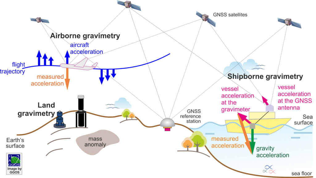
Gravimetry is the measurement of gravity, and gravity (also referred to as gravitation) is the universal force of attraction acting between all masses. On the Earth’s surface, gravity is a superposition of the gravitational attraction of masses and the centrifugal acceleration due to the rotation of the Earth. Gravity measurements can be based on the analysis of satellite orbits, using sensors on dedicated gravity satellite missions, or using terrestrial techniques, specifically, airborne gravimetry, shipborne gravimetry and land-based gravimetry. The acceleration of an object under the influence of Earth’s gravity, g, ranges from approximately 9.78 ms−2 (at the equator) to about 9.83 ms−2 (at the poles).
Absolute Gravity Observations
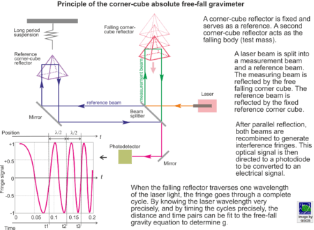
A gravity measurement can be either absolute or relative. Absolute gravity observations are performed with instruments that directly measure the magnitude of the acceleration of gravity. Because their length and time measurements can be tied to traceable, metrological standards, absolute gravity meters provide the full field gravity value at a given location and time, e.g. 9.8xx xxx xx ms-2. Modern instruments can measure g with an accuracy of about 1 x 10⁻⁸ ms-2 (i.e. nine digits, or about 1 part per billion). Absolute gravimeters can be further classified as either classical or quantum gravimeters, but both rely on precisely tracking the trajectory of a freely falling test mass. Classical instruments track the trajectory of a reflector in a vacuum chamber using laser interferometry, while quantum gravimeters measure the acceleration of free falling cold atoms (as test masses). [Link to quantum gravimetry]
Relative gravity measurements
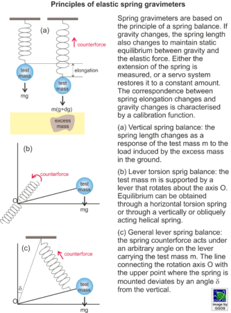
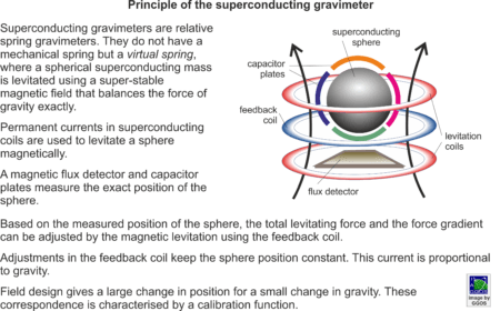
Relative gravity measurements provide either the difference in gravity between two locations or the change in gravity over time at a fixed location. While they do not provide the full field (“9.8”) gravity, modern relative instruments can still provide differences with the same parts-per-billion precision as absolute gravimeters. Relative gravimeters use a counterforce to keep a test mass in equilibrium with gravity. Gravity changes (in space or time) are inferred from the corresponding changes of the counterforce. In classical relative gravimeters, the test mass is suspended by using an elastic spring (usually made of metal of quartz). The gravity difference between two points (or at two different times) results in an elongation or contraction of the spring. In modern relative gravimeters, the test mass is held fixed by electric plates, and the electric force necessary to do this is a measure of the change in gravity. Another type of relative gravimeter is the superconducting relative gravity meter. Here, the elastic spring is realized by the magnetic levitation of a superconducting sphere in the super-stable magnetic field of a superconducting electromagnet. The magnetic levitation is designed to provide independent adjustment of the total levitating force and the force gradient so that it can support the full weight of the sphere and still yield a large displacement for a small change in gravity. Gravity changes are then inferred from the current adjustments needed to keep the sphere position constant.
Due to the high sensitivity of current gravimetry technologies and the many factors influencing absolute and relative gravity measurements, a conventional gravity reference system is required to provide a global standard of high metrological quality, serving as basis for global, regional and local gravity measurements. Presently, this standard is to be embodied by the International Gravity Reference System (IGRS) and it is realized by the establishment of absolute gravity reference stations.
Applications
Time and space-dependent changes of gravity yield information on the distribution and movement of Earth’s masses. Time series of gravity measurements play a central role in modelling and monitoring geodynamic and geophysical processes. Satellite gravimetry provides a unique, global, and homogeneous data set of mass anomalies within Earth or at its surface. However, current satellite gravimetry is unable to resolve structures smaller than a few hundred kilometers. To increase the spatio-temporal resolution of the satellite gravimetry and to be able to detect short-term and small-scale mass changes, terrestrial gravimetry is essential. Terrestrial gravimeters are able to detect mass distribution changes nearby, in a radius of a few hundred meters from the instrument. Thus, terrestrial gravimetry is an important tool to monitor low-frequency seismicity, volcanic systems, geothermal reservoirs, effects of irrigation or withdrawal of water, impacts of large building projects, etc. (see gravity field and temporal variations). Terrestrial gravimetry is also essential for geophysical prospection and it is widely used in the exploration of natural resources like oil and gas, as well as in mining and in geotechnical, archeological, metrological and geomatics studies.
In Physical Geodesy, terrestrial gravimetry is necessary for
– The establishment and maintenance of the International Height Reference Frame (IHRF)
– The establishment and maintenance of the International Gravity Reference Frame (IGRF)
– The high-resolution regional gravity field modeling resulted in the determination of a high-accuracy and high-precision geoid or quasi-geoid models
Service
Additionally, in the frame of the International Association of Geodesy (IAG), the Commission 2 “Gravity Field”, the Inter-Commission Committees “on Theory” and “on Geodesy for Climate Research”, as well as the recent established project “Novel Sensors and Quantum Technology for Geodesy (QuGe)” lead current research on advancing science and analysis to improve the observation and modelling of Earth’s gravity field.


