GNSS Reflectometry
GNSS Reflectometry (GNSS-R) is a remote sensing technique, exploiting GNSS signals reflected from the Earth’s surface. A large variety of geophysical parameters can be monitored using GNSS-R measurements on different ground-based, airborne, and spaceborne platforms.
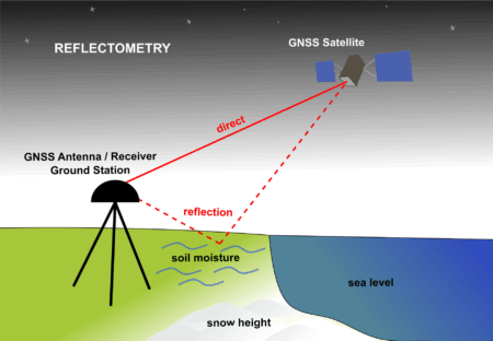
Figure 1: Principle of reflectometry using geodetic ground stations [Figure by M. Sehnal, ©GGOS]
GNSS-R with geodetic ground stations
The reflected signals from the surface cause patterns in GNSS measurements of geodetic ground stations (Figure 1). These patterns mainly appear when the GNSS satellite is near the horizon, i.e. at low elevation angles. The frequency and amplitude of these patterns are dependent on the surface state and can be therefore used to obtain information on e.g. sea level height, soil moisture, snow depth, and vegetation growth. It is consequently known that not only the existing GNSS signals but also existing GNSS networks, originally developed for geodetic applications, can be employed for such remote sensing purposes.
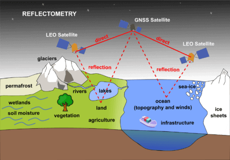
Figure 2. Principle of GNSS reflectometry using receivers on satellites. [Figure by M. Sehnal, ©GGOS]
GNSS-R with GNSS receivers on satellites
After several airborne experiments and pieces of evidence on the feasibility of tracking reflected signals onboard spaceborne platforms, the GNSS-R demonstration satellite missions, UK-DMC and TechDemoSat-1 were launched in 2003 and 2014 respectively. The receiver onboard these satellites cross correlated the reflected signal with a replica generated locally; this technique is known as conventional GNSS-R (cGNSS-R). The cross-correlation power was mapped in a range of delay and Doppler frequency shifts to create so-called delay-Doppler Maps (DDMs). The power in the DDMs and their shape are controlled by the type of reflecting medium and its properties. For instance, the inverse correlation of the power with ocean surface roughness, and consequently surface wind speed, motivated the main objective of NASA Cyclone GNSS (CYGNSS) launched in late 2016. CYGNSS is a constellation of eight microsatellites fully dedicated to GNSS-R for ocean surface and wind monitoring. The energy of GNSS L-band signals is insignificantly attenuated with raindrops and clouds in the atmosphere, which is the advantage taken by CYGNSS to observe tropical cyclones and hurricanes. The main goal of the first GNSS-R space missions was indeed the monitoring of ocean surface and wind state; i.e., ocean scatterometry. However, the spaceborne GNSS-R currently offers much varied applications, over not only ocean, but also over land and the cryosphere; and therefore, it plays a central role in their characterization and to infer relevant climate signals and possible natural hazards. The spaceborne measurements are additionally used for monitoring of e.g. soil moisture, sea level height, vegetation state, ice, and glaciers (Figure 2).
The implementation of GNSS-R requires only the receiver component which leads to competitive cost-effectiveness. The unprecedented sampling rate, due to the implementation onboard multiple-satellite constellations, encourages different ideas for a variety of applications. Several GNSS-R spaceborne missions are emerging with a variety of objectives and different observation concepts, e.g. cross-correlation of the reflected signal with that directly received, instead of the replica, known as interferometric GNSS-R (iGNSS-R). Further potentials are still being explored and the implementation of the technique onboard CubeSats is a recent promising development.


