GNSS Radio Occultation
During the last two decades, the satellite-based GNSS radio occultation technique has been developed as an innovative remote sensing method for vertical profiling of the Earth’s lower and upper atmosphere on a global scale with numerous applications, e.g. in tropospheric, ionospheric, space weather and climate sciences.
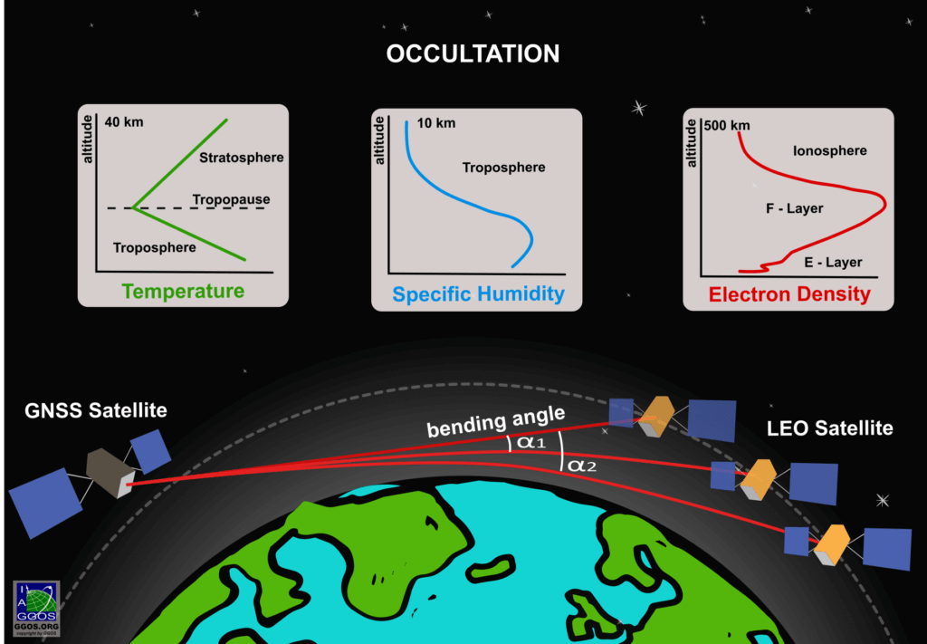
Figure 1: Vertical profiling of the Earth’s lower atmosphere (troposphere, stratosphere) and upper atmosphere (ionosphere) by means of GNSS occultation measurements. [Figure by M. Sehnal ©GGOS]
With a GNSS receiver onboard a low-Earth orbiting (LEO) satellite with an altitude of less than 1000 km, the signal transmitted by a GNSS satellite can be received by the LEO satellite passing through the Earth’s atmosphere in a limb sounding geometry. This refers to the GNSS Radio Occultation (GNSS-RO) technique, which allows to observe global characteristics of the Earth’s lower and upper atmosphere, with a unique combination of global coverage, high precision, high vertical resolution, long-term stability, and all-weather viewing (occultation, Latin: occultare: to cover something).
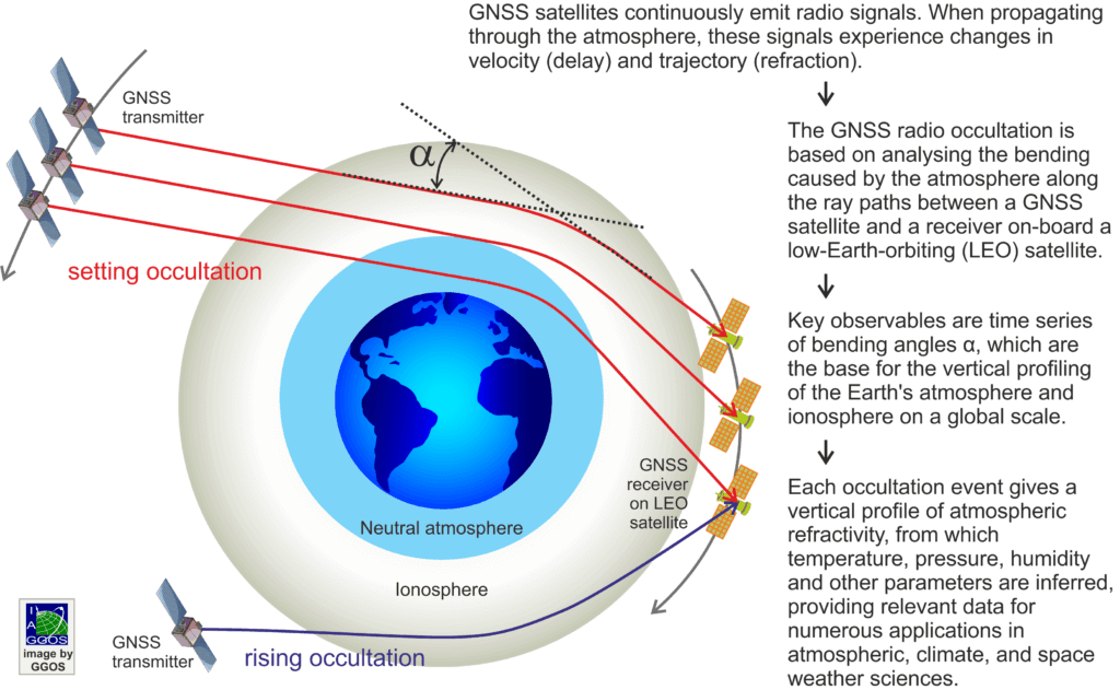
As can be seen from Fig. 1 the signal source, i.e. the GNSS transmitter, can reach an elevation angle below zero from the LEO receiver perspective. It is distinguished between setting and rising occultations as defined by increasing or decreasing signal elevations, i.e. the signal bending (see Fig. 2). The strength of bending will change due to the vertical variation of the atmospheric refractive index. In the neutral atmosphere, the refractive index is depending on temperature and humidity, in the ionosphere on the electron density. For the evaluation of the RO measurements the precise knowledge of LEO and GNSS satellite positions and velocities is required.
Final data products of GNSS-RO are refractivity, air pressure, and temperature profiles in the altitude range up to around 40 km and the lower troposphere water vapor information, as well as electron density profiles from 60 km up to the LEO orbital height. With only one LEO satellite, around 500 globally distributed atmospheric profiles are available daily for “GPS-only” usage. With a multi-GNSS capability of the satellite receiver (also considering, e.g. Galileo satellites) this number increases significantly.
Figure 2: Setting and rising GNSS Radio Occultation scenarios for monitoring the upper atmosphere (ionosphere) and the lower atmosphere (neutral atmosphere). [Figure by L. Sánchez ©GGOS]
Applications
In the lower troposphere, GNSS-RO measurements can be used for the estimation of the planetary boundary layer height and for the determination of tropospheric water vapor. All leading weather service centers assimilate GNSS-RO data and there is a significant high impact of GNSS-RO data for the reduction of forecast errors.
The high accuracy of global GNSS-RO observations in the upper troposphere and lower stratosphere (UTLS) make them ideal for lower atmospheric and climate applications as well as for weather forecast. To be more specific, long-term GNSS-RO data are used for climate monitoring and trend detection in the UTLS and serve as benchmark data for the validation and calibration of other satellite datasets. The high vertical resolution of GNSS-RO observations allows for studying the tropopause dynamics and related UTLS phenomena like gravity wave analysis.
A precise knowledge of the electron density as the most important key parameter of the ionosphere is essential for ionosphere research. It also plays a crucial role in a wide range of applications, e.g. positioning, navigation and autonomous driving. Ionosphere is also seen as a manifestation of space weather, i.e. it reflects the response of the Earth to solar phenomena such as solar wind and coronal mass ejections.
The thermosphere coincides with the region of highest ionization (see Fig. 3). Consequently, strong physical interactions exist between the thermospheric neutral density as the most important non-gravitational quantity in precise orbit determination of LEO satellites and the electron density of the ionosphere.
Infrastructure
The US GPS/MET mission (launch 1995) was pioneering the GNSS-RO technique and provided the proof-of-concept. The international breakthrough of GNSS-RO for operational applications came with the German satellite CHAMP, which was launched on July 15, 2000 and delivered highly accurate observation data in near-real time until the end of the mission in 2010. Important follow-on missions are Formosat-3/COSMIC, Metop, GRACE, GRACE-FO, TerraSAR-X/TanDEM-C and Formosat-7/COSMIC-2. Recently, also commercial satellite operators such as SPIRE provide GNSS-RO data with high quality from small satellite constellations.
Figure 3: Stratification of the atmosphere according to the altitude (left), the temperature (mid) and the ionization (right). [Figure by L. Sánchez ©GGOS]
Further Information
In the frame of the International Association of Geodesy (IAG), the following components concentrate on advancing sciences and applications of GNSS-RO:
Additional (selected) sources are:


