Global Navigation Satellite Systems
GNSS
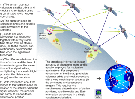
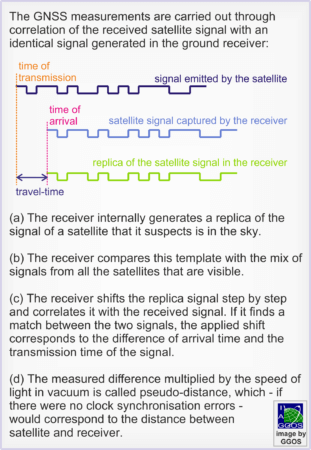
GNSS positioning is based on measuring signal travel times to determine distances (or ranges) between satellites and receivers. The satellites continuously emit radio waves as carrier of signals. These microwaves contain time stamps generated by very precise atomic clocks on board the satellites. The receiver on (or close to) Earth captures the satellite signals and registers their time of arrival. The difference between the time of arrival and the time of emission provides the signal travel time, which, multiplied by the speed of light, provides the distance between the (unknown) position of the receiver and the (known) position of the satellite.
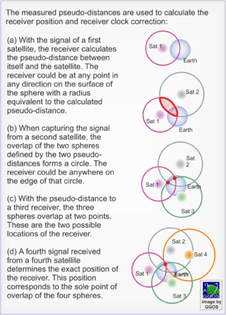
The measurements are carried out through correlation of the received satellite signal with an identical signal generated in the ground receiver. The difference between the received and the generated signal is directly proportional to the travel time of a signal from satellite to the receiver. As the clocks of the satellite and the receiver are not synchronised, the original distances derived from the travel time of a signal are known as pseudo-ranges.
To ensure a reliable determination of the distance satellite-receiver, clocks in satellites and receivers have to be synchronised at the level of a nanosecond to tens of picosecond. The atomic clocks in the satellites are synchronised by the system operators. The synchronisation values are known as satellite clock corrections. The synchronisation of the receiver clocks with the satellite clocks is performed together with the determination of the receiver position. For this, the receiver has to measure the signals from at least four satellites simultaneously.
As the satellite positions and clock corrections have to be known, the system operator calculates the satellite orbits from the observations of some GNSS ground stations. The operator then loads the calculated orbits and satellite clock corrections to the satellites and they are transmitted together with the signal time stamps to the Earth. This so-called broadcast information has an accuracy of about one metre for all GNSS systems and is usually employed for navigation applications. For the precise observation of the Earth, however, orbits and clock corrections in the centimetre and picosecond ranges are required. Since the satellite operators do not provide this highly precise information, geodesists calculate it themselves. This is not easy. To calculate precise satellite orbits exact positions of ground stations are needed. Conversely precise satellite orbits are needed to determine the exact station positions. The solution is the simultaneous determination of station positions and satellite orbits in a single consistent calculation, so that station coordinates and satellite orbits are given in the same reference frame.
When propagating through the atmosphere, the GNSS signals experience changes in velocity and trajectory (refraction) and arrive the ground stations with some delay. This delay may be misunderstood as a longer distance between signal source and receiver and therefore, additional parameters describing the perturbation of the signals in the atmosphere are included in the data analysis. The latter makes it possible to use geodetic measurements to determine the density of free electrons in the ionosphere and to provide tropospheric parameters to monitor the water vapour contents in the lower atmosphere.
In general, GNSS currently consists of a constellation of about 100 medium Earth orbit (MEO) satellites mostly, which orbit the Earth at an altitude of about 20,000 to 26,000 kilometres in roughly half a day. The satellites are distributed in different orbital planes with an inclination larger than 55 degrees with respect to the Earth’s equatorial plane. This arrangement makes it possible that several satellites are visible at any time and at any place worldwide. Thus, they ensure a global coverage. There are also a number of geostationary Earth orbit (GEO) and inclined geosynchronous orbit (IGSO) satellites among some of the GNSS constellations. The United States’ Global Positioning System (GPS) was the first GNSS that became fully operational worldwide in 1993. Today, Russia’s Global’naya Navigatsionnaya Sputnikovaya Sistema (GLONASS), China’s BeiDou Navigation Satellite System (BDS), and the European Union’s Galileo are also fully operational. Additionally, there are two regional GNSS (based on geostationary and geosynchronous satellites) in Japan (Quasi-Zenith Satellite System – QZSS) and in India (Indian Regional Navigation Satellite System – IRNSS, also known as Navigation Indian Constellation – NavIC).
Applications
Since GNSS are an all-weather, real-time, continuously available, economic and very precise positioning technique, almost unlimited possibilities are opened up for its use in Geodesy, surveying, navigation and related fields, including: control surveys, geodynamics, altitude determination, cadastral surveying and GIS (Geographic Information Systems), monitoring and engineering, precise navigation, photogrammetry and remote sensing, marine and glacial Geodesy, etc. GNSS are today a central part of daily life by supporting not only location-based services with smart telephones or similar electronic devices, but also terrestrial, aerial and marine navigation, agriculture, monitoring of migratory or endemic animal species, etc.
GNSS also play a central role in the observation of the System Earth as they have two essential advantages with respect to the other geodetic positioning space techniques: GNSS receivers are portable and very much cheaper than VLBI, SLR or DORIS equipment. Today, GNSS are widely applied for deformation monitoring of natural hazards (volcano eruptions, seismic effects, landslides, subsidence, etc.), man-made structures (dams, buildings, bridges, mines, etc.), and also modelling tectonic features (plate motion, surface deformation, slow-slip interactions, etc.) including vertical movements associated to mountain building and global isostatic adjustment (GIA). Recent improvements in the GNSS technology and in the data processing strategies increase sensitivity and accuracy of the GNSS results, and today it is even possible to detect small signals of surface deformations caused by oceanic, hydrologic, or atmospheric loading. Since the propagation of electromagnetic waves is disturbed by the charged particles within the atmosphere, GNSS measurements can be used to develop high-resolution ionosphere models. Real-time monitoring of the electron density distribution in the ionosphere is of increasing importance not only for modern applications such as autonomous driving and precision agriculture, but also for forecasting space weather events. Additional scientific applications of GNSS are GNSS reflectometry (GNSS-R), GNSS Scatterometry and GNSS Radio-Occultation.
Services
The International GNSS Service maintains and processes a global continuously operating GNSS network as a core ground component for the determination of precise satellite orbits, satellite/receiver clock corrections, Earth orientation parameters, atmospheric parameters, and station positions and velocities. The primary data provided by the IGS is GPS and other GNSS (where available) measurements in the form of RINEX (Receiver Independent Exchange Format) files for each of the stations forming the IGS network. Other data includes broadcast ephemerides (orbits) for GNSS satellites and station meteorological information. Updated station data is available on a daily basis. Satellite orbits, and satellite and station clock data, as well as Earth orientation parameters products are determined by the IGS analysis centres and combined as the IGS products, which are available at various latencies to reflect the requirements of different applications. Ultra-rapid products are available in near real-time, but are the least precise. Rapid products are provided within one to two days and have greater precision. The final products provide the best precision and are available within ten days to three weeks (depending on the product). The International Earth’s Rotation and Reference System’s Service (IERS) combines the GNSS products of highest quality generated by the IGS with the contributions from other space techniques to determine the terrestrial reference frame and the Earth orientation parameters.


