Doppler Orbitography and Radiopositioning
Integrated by Satellite
DORIS
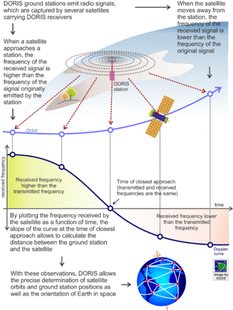
DORIS employs the Doppler Effect to determine the distance between ground stations and satellites orbiting the Earth. If the positions of the ground stations are known, the DORIS measurements allow a precise determination of the satellite orbit. The DORIS ground stations continuously emit radio signals, which are captured by several satellites carrying DORIS receivers. When a satellite approaches a station, the frequency of the received signal is higher than the frequency of the signal originally emitted by the station. When the satellite moves away from the station, the frequency of the received signal is lower than the frequency of the original signal. At the time of closest approach, when the satellite is upright the DORIS station, the transmitted and the received frequencies are the same. By plotting the frequency received by the satellite as a function of time, the slope of the curve at the time of closest approach allows to calculate the distance between the ground station and the satellite.
DORIS was developed by the French Space Agency CNES (Centre National d’Études Spatiales), in cooperation with the Institut Géographique National (IGN) for precise orbit determination for low-altitude Earth satellites. The system measures the Doppler shifts in radio signals, transmitted by ground beacons and received by the DORIS on-board package as the satellites passes overhead. A receiver on-board the satellite captures the signal and measures the Doppler shift over a short count interval, namely every 10 seconds. The data are time tagged with respect to an ultra-stable on-board crystal oscillator. The ground stations are also equipped with stable oscillators and sensors to provide in-situ meteorological data. The average precision of the range rate observations is about 0.3 mm/s (radial velocity). The DORIS system comprises:
- The on-board package, consisting of a receiver, an ultra-stable crystal oscillator and an omnidirectional antenna,
- A global network of permanent ground stations, at about 60 sites, enabling orbitography and positioning, each consisting of a dual-frequency transmitter (2 GHz + 400 MHz), an ultra-stable oscillator, remote control system, meteorological sensors, and a transmitting antenna including the station marker (antenna reference point),
- Several master stations, providing the time reference for the system, and
- A control segment managed by the control centre domiciled in Toulouse, France.
Network of DORIS
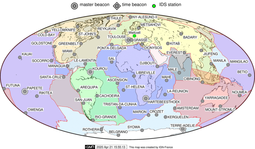
The DORIS permanent stations are homogeneously distributed around the globe, including the oceans as nearly half or the stations are on islands or in coastal areas. This is a key factor in the high quality of the DORIS products because this distribution assures an 80% coverage of user satellite orbits near 800 km altitude, and a 95% coverage of user satellite orbits at 1,335 km altitude. All measurements are collected by the on-board receiver, stored in the on-board memory, and download at regular time intervals to the control centre in Toulouse.
Applications
A major product of the DORIS system is the precise orbit determination for low-altitude Earth satellites, which are especially dedicated to altimetry and remote sensing. In these missions, high-quality orbits are fundamental to ensure, among others, an accurate mapping of the ocean surface and to determine variations of the global sea level. Currently, precise orbit determination with DORIS is possible with cm-accuracy. Once the satellite orbits are known, the exact position of a DORIS station anywhere in the world can be calculated. As the DORIS equipment is simple, robust and in continuous duty, they operate unattended for several months. The stations do not require any connection for the data transfer. The automatic monitoring of the beacons make the system well suited for use in high-risk areas or regions with poor infrastructure. The permanent station network delivers high-precise 3D coordinates for geodetic and geodynamic applications. Positions and motions are available to better than 1 cm and 1 mm/year, respectively. Due to the dense and homogeneous global station network, DORIS significantly contributes to the realization and maintenance of the International Terrestrial Reference Frame (ITRF). Around 50 of the more than 60 DORIS stations are co-located with other space techniques (VLBI, SLR, GNSS). Additional key contributions of DORIS are
- time series of Earth orientation parameters (UT1 time rates, polar motion and polar motion rates)
- geocentre monitoring and scale information
- tectonic plate motions and surface deformation
- vertical displacements near tide gauges
- gravity field improvement
- ionospheric studies and models of the total electron contents in the Ionosphere
- atmospheric drag.
Services
The International DORIS Service (IDS) provides high-quality data and products related to the DORIS techniques in view of geodetic and geophysical research activities, in particular, for the precise orbit determination for altimeter mission satellites and the determination of the International Terrestrial Reference Frame (ITRF). The contribution of the DORIS system to the determination of the ITRF and the Earth orientation parameters is combined with the contributions from other space techniques by the International Earth’s Rotation and Reference System’s Service (IERS).


