GGOS
  • About
    • About GGOS
      • What is GGOS?
      • Why GGOS?
      • Dual Roles of GGOS
      • Vision and Mission
      • GGOS History
      • Organization Structure
        • Managing Body
        • Coordinating Office CO
        • Science Panel
        • Bureaus
        • Focus Areas
        • GGOS Affiliates
        • GGOS Committees & Working Groups
  • Observations
  • Services
    • Geometric & General Services
      • IGS – Int. GNSS Service
      • ILRS – Int. Laser Ranging Service
      • IVS – Int. VLBI Service
      • IDS – Int. DORIS Service
      • IERS – Int. Earth Rotation and Reference Systems Service
      • PSMSL – Permanent Service for Mean Sea Level
    • Gravity Services
      • IGFS – Int. Gravity Field Service
      • ICGEM – International Centre for Global Earth Models
      • IDEMS – International Digital Elevation Model Service
      • IGETS – International Geodynamics and Earth Tide Service
      • ISG – International Service for the Geoid
      • BGI – International Gravimetric Bureau
  • Products
  • Events
    • Events
      • Upcoming Events
      • Past Events
      • Calendar
  • Blog
    • GGOS Blog – News
      • News
      • Article
      • Introduction
    • Newsletter
    • GGOS Cloud
    • Terms of References and Strategy
    • Reports and Articles
    • Presentations and Poster
    • Graphics and Images
  • Click to open the search input field Click to open the search input field Search
  • Menu Menu
  • Link to X Link to X Link to X
  • Link to Youtube
  • Link to LinkedIn
  • Link to Facebook
  • Link to GGOS Newsletter
  • Link to Email - Contact GGOS
  • ABOUT
    • What is GGOS?
    • Why GGOS?
    • Dual Roles of GGOS
    • Vision and Mission
    • GGOS History
  • ORGANIZATION
    • Structure Overview
    • Managing Body
      • Overview
      • Executive Committee EC
    • Coordinating Office CO
    • Bureaus
      • Overview
      • BNO – Bureau of Networks and Observations
      • BPS – Bureau of Products and Standards
    • Focus Areas
      • Overview
      • Unified Height System
        • Introduction
        • Presentation
        • Objectives
        • Activities
        • Working Groups
        • Further Reading
      • Geohazards
      • Geodetic Space Weather Research
        • Introduction
        • Objectives
        • Joint Study Groups
    • GGOS Affiliates
      • Overview
      • GGOS Japan
    • GGOS Committees & Working Groups
    • Science Panel
  • OBSERVATIONS
  • PRODUCTS
  • SERVICES
  • EVENTS
    • Upcoming Events
    • Past Events
    • Calendar
  • BLOG – News
  • GGOS DOCUMENTS
    • GGOS Cloud
    • Terms of References and Strategy
    • Reports and Articles
    • Presentations and Poster
    • Graphics and Images

GGOS Strategic Plan Survey

You are here: Home1 / GGOS Strategic Plan Survey
Survey Introduction

Introduction

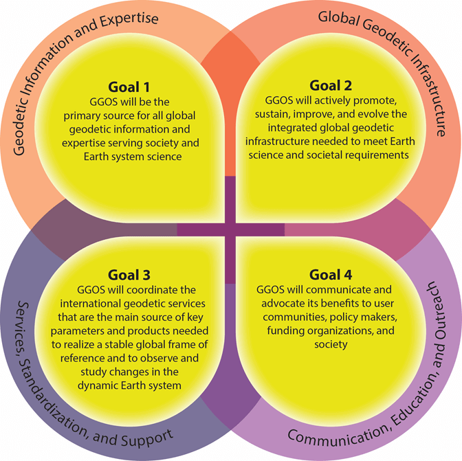
As the observing system of the International Association of Geodesy (IAG), the Global Geodetic Observing System (GGOS) (see details in “Discover GGOS” film below) serves a unique and critically important combination of roles – centering upon advocacy, integration, and international relations. GGOS also promotes high-level outcomes, such as the realization of the International Terrestrial Reference Frame through a variety of internal and external channels.

GGOS focuses attention on how international geodesy needs to evolve in order to deliver an order of magnitude improvement in the quality of its fundamental products – this includes identifying the critical elements of global physical infrastructure, efficient data management, and combined measurement analysis. The IAG tasks GGOS to advocate for improvements in ground-based geodetic infrastructure as well as promoting the importance of modern geodesy for addressing the needs of science and society for stable spatial and temporal geodetic reference frames.

GGOS internally integrates the geometric and gravimetric aspects of geodesy – driving continuous improvement in the quality of geodetic products through increased cooperation between different geodetic techniques. GGOS also works with the IAG Services, Commissions, Inter-Commission Committees and Projects to address fundamental scientific issues facing the geodesy community.

Externally, GGOS advocates the visibility of geodetic contributions to Earth observation systems, and serves as a communication bridge between the scientific infrastructure of the IAG and an ever-growing user community who needs geodetic data and products. GGOS is also a strong supporter of the United Nations Global Geodetic Reference Frame, and in particular the UN GGIM Subcommittee on Geodesy.

As GGOS reaches its 20th anniversary of service to the IAG and global geodesy community, we need your input to inform and guide the goals of the next GGOS Strategic Plan. Your contribution is highly appreciated. Please participate in this survey until September 30, 2022.

>> Start Survey <<

GGOS Strategic Areas & Goals

Overarching Strategic Areas and Goals of GGOS

These strategic areas were presented in the current GGOS Strategic Plan from 2014: View this GGOS Strategic Plan

1. Geodetic Information and Expertise

Support the development and maintenance of organizational intangible assets, such as community engagement, capacity development, and education.

2. Global Geodetic Infrastructure

Development of, advocacy for, and maintenance of global geodetic infrastructure.

3. Services, Standardization, and Support

Promote coordination, support, and efficient utilization of the existing geodetic infrastructure, as well as existing IAG resources.

4. Communication, Education, and Outreach

Marketing, outreach, and engagement to sustain and grow the organizational impact of GGOS.

>> Go to the Survey <<

Survey Form

Survey Form

Your contribution is highly appreciated. Please take 10-15 minutes to participate in this survey until September 30.

For more information, please see the Introduction and the current Strategic Areas and Goals of GGOS.

The GGOS Strategic Plan Survey is over. The results will be discussed at the Strategic Planning Workshop.


GGOS is a part of the IAG and the IUGG

References

Terms of Use (Website)

GGOS Terms of References

GGOS Strategic Plan


Follow Us

Linked In

BlueSky

X (Twitter)

Facebook

YouTube

RSS Feed

Interesting Pages

GGOS Blog – News

Documents of GGOS

Internal Links

GGOS Cloud

Webmail

Admin Area

This website is provided by the GGOS Coordinating Office, which is hosted by the BEV – Federal Office of Metrology and Surveying in Vienna, Austria.

Contact Us

Email to GGOS

2025 © Copyright - GGOS Global Geodetic Observing System
  • Link to X Link to X Link to X
  • Link to Youtube
  • Link to LinkedIn
  • Link to Facebook
  • Link to GGOS Newsletter
  • Link to Email - Contact GGOS
Scroll to top Scroll to top Scroll to top