IGS – International GNSS Service
For over twenty-five years, the International GNSS Service (IGS) has carried out its mission to advocate for and provide freely and openly available high-precision GNSS data and products. IGS was first approved by its parent organization, the International Association of Geodesy (IAG), at a scientific meeting in Beijing, China, in August of 1993. A quarter century later, the IGS community gathered for a workshop in Wuhan, China, in October/November 2018 to blaze a path to Multi-GNSS through global collaboration.
At the heart of the IGS is a strong culture of sharing expertise, infrastructure, and other resources for the purpose of encouraging global best practices for developing and delivering GNSS data and products all over the world. The collaborative nature of the IGS community, which as of 2019 includes over 140 GNSS stakeholder organizations from 45 countries leverages this diversity to integrate and make full use of all available GNSS technologies while promoting further innovation. Over 15,000 product users, some of whom comprise the backbone of the worldwide geodetic community, ensure that new technologies and systems are integrated into routine IGS products. Responsive to this innovation, the IGS develops and publicly releases standards, guidelines, and conventions for the collection and use of GNSS data and products.
Mission
The Mission of the IGS is to “provide on an openly available basis, the highest-quality GNSS data, products, services in support of the terrestrial reference frame; Earth observation and research; Positioning, Navigation and Timing (PNT); and other applications that benefit the scientific community and society.”
In 2019, the IGS adopted an official slogan: “Providing openly available GNSS data and products that benefit science and society,” as well as an official organizational vision: “A better understanding of the Earth through the application of GNSS.”
IGS report at the GGOS Days 2023
Network
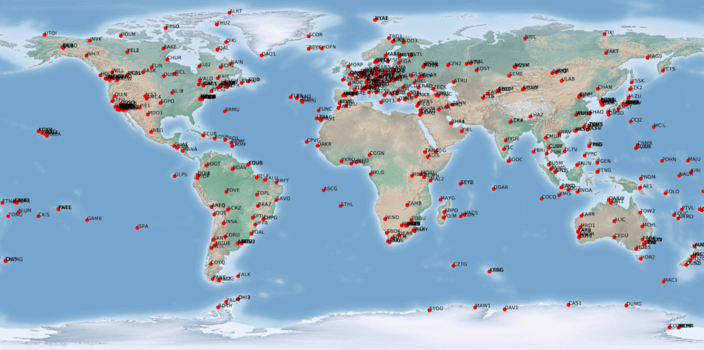
The foundation of the IGS is a global network of over 500 permanent and continuously operating stations of geodetic quality. These stations track signals from GPS, and increasingly also track signals from GLONASS, Galileo, BeiDou, QZSS, NavIC (IRNSS) as well as space-based augmentation systems (SBAS). As of late 2019, the IGS has 506 Stations, of which 308 are Multi-GNSS stations, and 259 Real-time stations. The percentage of multi-GNSS capable IGS network is expected to grow in the coming years.
Role in the International Association of Geodesy
It is a service of the International Association of Geodesy (IAG) and is a collaborative effort involving dozens of scientific, academic and government organizations. The IGS is a critical component of the IAG’s Global Geodetic Observing System (GGOS), where it facilitates cost-effective geometrical linkages with and among other precise geodetic observing techniques, including: Satellite Laser Ranging (SLR), Very Long Baseline Interferometry (VLBI), and Doppler Orbitography and Radio Positioning Integrated by Satellite (DORIS). These linkages are fundamental to generating and accessing the International Terrestrial Reference Frame (ITRF).
Alignment with the ITRF
The IGS provides the GPS coordinates, velocities and ERPs that contribute to the International Terrestrial Reference Frame (ITRF). GNSS has an important role providing connections between the other space geodesy techniques (VLBI, SLR and DORIS). It also helps maintain the orientation of the ITRF.
Utilizing the data and products of the IGS enables high-precision positioning to be carried out over large areas by utilizing the International Terrestrial Reference Frame (ITRF).
Structure
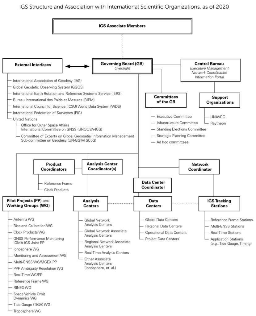
There are five main operational components to the IGS: data providers, data centers, analysis centers, working groups and the central bureau. These are described in further detail in the chart below:
Data and Analysis Products
The primary data provided by the IGS is GPS and GLONASS (where available) code and phase measurements in the form of RINEX files for each of the stations forming the IGS network. Other data includes broadcast ephemerides (orbits) for GPS and GLONASS and station meteorological information. Updated station data is available on a daily basis.
The IGS products are derived from this data. These include precise ephemerides, satellite/receiver clock corrections, Earth Rotation Parameters (ERPs), atmospheric param-eters, station coordinates and station velocities. Products are available at various latencies to reflect the requirements of different applications. Ultra-rapid products are available in near real-time, but are the least precise. Rapid products are provided within one to two days and have greater precision. The final products provide the best precision and are available within ten days to four weeks (depending on the product).The IGS also provides antenna calibration data for antennas in its network and site logs containing station metadata.
Geoscience Australia and the Massachusetts Institute of Technology jointly manage the IGS Analysis Center Coordination (ACC), with operations based at Geoscience Australia in Canberra, Australia. The ACC combination software is housed on cloud-based servers located in Australia and Europe, and coordination of the IGS product generation continues to be carried out by personnel distributed between GA and MIT. Under this joint management, the IGS continues to maintain a very high level of product availability.
Further Information
For additional information, including information about joining Working Groups or attending IGS meetings and events, please visit the IGS website, www.igs.org, and follow us on twitter @IGSorg.
(last update 2020)


