Geodetic Observations
Space Techniques
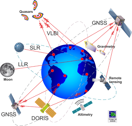
Very Long Baseline Interferometry (VLBI) observations to extragalactic radio sources (quasars: quasi-stellar radio sources, radio galaxies) and tracking of MEO and GEO satellites are fundamental to the maintenance and improvement of the geodetic reference frames and the determination of Earth orientation. The combination of VLBI and satellites tracking provides the connection between the celestial and terrestrial reference frames.
Satellites used for geodetic observations differ in design, equipment and orbital parameters according to the mission purpose. Satellites can be regarded as moving targets at high altitude and then used for positioning and navigation. Since the satellite orbits are sensitive to the gravitational field of the Earth, the satellites also serve as a sensor for gravitation.
Space geodetic techniques are essential for providing accurate and long-term stable global reference frames and to observe and understand Earth dynamics. Each space geodetic technique is sensitive to different Earth signals, conducts observations with different resolutions in space and time, and provides geodetic products with different latency and quality.
Satellites at high altitudes (MEO and GEO) are preferred for positioning, as they are less influenced by gravitational and air drag perturbations. Satellite-based geodetic techniques that play an essential role in the precise satellite orbit determination, the establishment and maintenance of global reference frames, the determination of Earth orientation and the modelling of the long-wave part of the Earth’s gravity field include Global Navigation Satellite Systems (GNSS), Satellite Laser Ranging (SLR) and Doppler orbitography and radio positioning integrated by satellite (DORIS).
Geodetic LEO satellites are preferred for determining the Earth’s gravity field (as they are more sensitive to short-wavelength gravity components) and to map the Earth’s surface (topography, oceans, ice caps, lakes, rivers, and soil moisture). Satellites have the big advantage that they collect data homogeneously and consistently over large parts of the Earth’s surface. They also allow the collection of data that cannot be recorded at the Earth’s surface. Observations based on LEO satellites are essential to monitor sea level, ice sheets, water storage on land, atmospheric water content, high-resolution surface motion and variation in the Earth’s gravity field.


